Where Wilderness Meets the World’s Third-Highest Mountain.

Kanchenjunga North & South Base Camp Trek

Kanchenjunga 23 days 5,150 m
Challenging

Journey deep into the remote eastern Himalayas on an extraordinary Kanchenjunga North & South Base Camp Trek. Trek through lush forests, traditional mountain villages, dramatic glaciers, and high Himalayan passes, reaching Pang Pema (5,140 m) and the spectacular Oktang viewpoint (4,730 m) beneath Mount Kanchenjunga, the world’s third-highest mountain. With carefully planned acclimatization days, challenging high-altitude crossings, and a rare combination of northern and southern base camps, this is an unforgettable adventure into one of Nepal’s most pristine and untouched mountain regions.

ActivitiesTrekking
Group SizeMin. 2 Pax

Trip Highlights

Reach Kanchenjunga North Base Camp (Pang Pema, 5,140 m) with breathtaking views of the world’s third-highest mountain.

Explore the South Base Camp & Oktang Viewpoint (4,730 m) for an unforgettable perspective of Kanchenjunga’s southern face.

Cross spectacular high passes, including Sele La (4,186 m) and Sinion La (4,646 m), through remote Himalayan wilderness.

Experience authentic mountain life through remote villages, Tibetan-influenced culture, forests, glaciers, and dramatic landscapes far from the busy trekking routes.

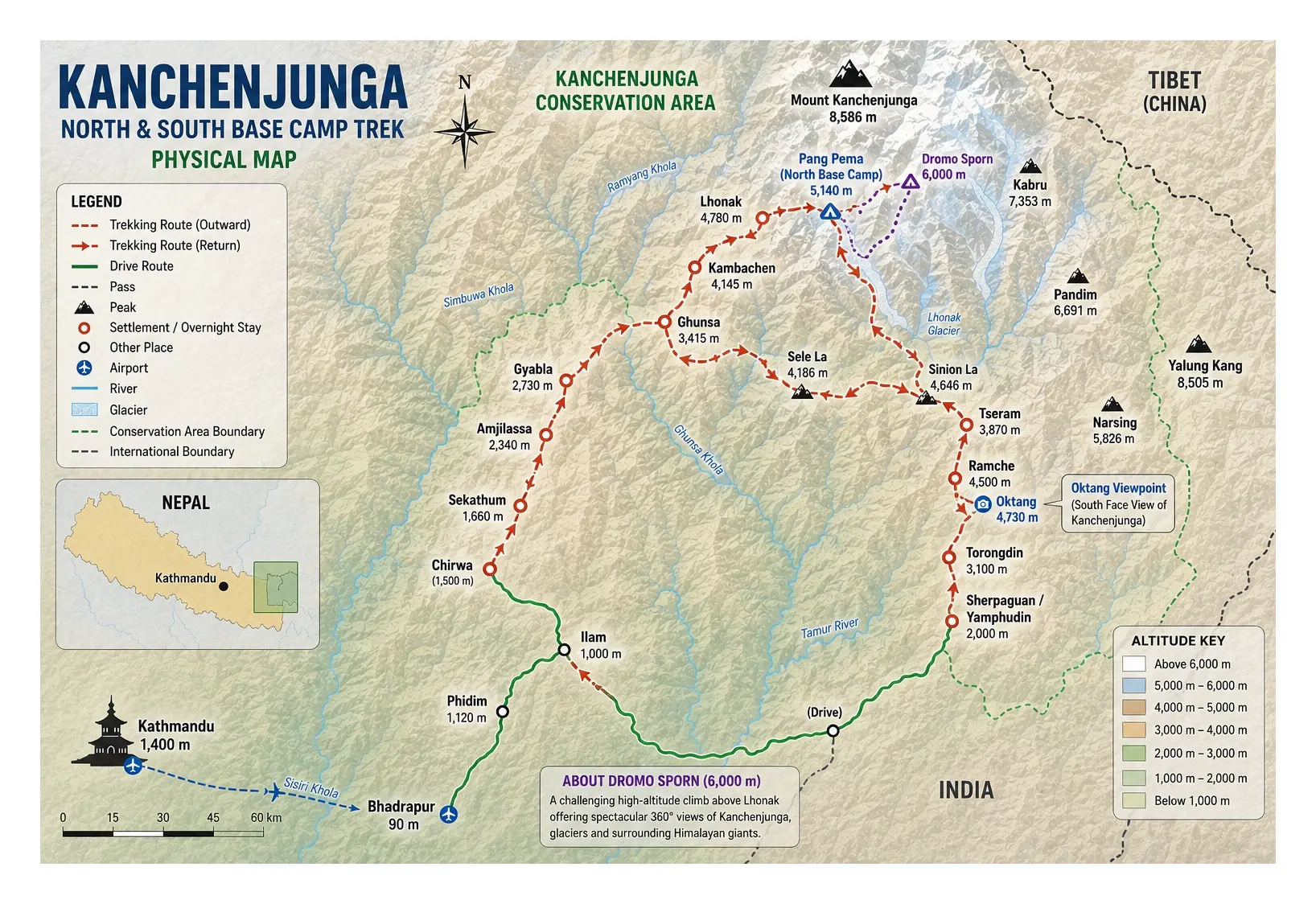
Route Plan

Itinerary

Altitude1,400 m

Welcome to Nepal! Upon your arrival at Tribhuvan International Airport in Kathmandu, our team will meet you and transfer you comfortably to your hotel in Thamel. After checking in, you can relax and recover from your journey or take a gentle walk through the lively streets of Thamel. This is a relaxed beginning to your Kanchenjunga adventure, giving you time to settle in, meet your trekking team, and prepare for the remote Himalayan journey ahead.

Transfer: Airport to hotel
Meals: Welcome Dinner

Duration6-7 Hrs
Distance265 km
Altitude1,120 m

Your adventure begins with a flight from Kathmandu to Bhadrapur in eastern Nepal. From Bhadrapur, the journey continues by road toward Phidim, passing through lush hills, winding mountain roads, and traditional settlements. The approximately 265 km drive takes around 6–7 hours, offering your first glimpse into the eastern Himalayan landscape. Phidim is a peaceful hill town and an important gateway toward the Kanchenjunga region.

Altitude: Phidim – 1,120 m
Flight: Kathmandu–Bhadrapur, approximately 45–50 minutes
Drive: Approximately 265 km | 6–7 hours
Meals: Breakfast, Lunch & Dinner
Overnight: Lodge

Duration3-4 Hrs
Altitude1,660 m

Today you continue deeper into eastern Nepal by road, following rugged mountain terrain toward the Kanchenjunga trailhead. Depending on road and local conditions, the drive takes you toward Chirwa or Sekathum, where the trekking adventure begins in earnest. The landscape gradually becomes wilder and more remote as you approach the Kanchenjunga Conservation Area. After reaching your overnight stop, take time to rest and prepare for the first full day of trekking.

Altitude: Sekathum - approximately 1,660 m
Drive: Distance and duration depend on the road conditions and overnight point
Walking: Short local walk, approximately 3 hours if required
Elevation change: Approximately +200 m / -200 m
Meals: Breakfast, Lunch & Dinner
Overnight: Lodge

Duration6-7 hrs
Distance12-14 km
Altitude1,660 m

Your first full day on the Kanchenjunga trail takes you through beautiful Himalayan foothills, where forested slopes, rushing rivers, suspension bridges, and small mountain settlements create an unforgettable introduction to the region. The trail gradually climbs and descends through a landscape that feels increasingly remote and untouched. With approximately 850 m of ascent and 50 m of descent, this is a demanding but rewarding day that builds the rhythm for the journey ahead.

Altitude: Sekathum - 1,660 m
Walking time: Approximately 6 hours
Elevation gain: +850 m
Elevation loss: -50 m
Distance: Approximately 12–14 km, depending on the exact trail
Meals: Breakfast, Lunch & Dinner
Overnight: Lodge

Duration6-7 hrs
Distance12-14 km
Altitude2,340 m

Today the trail enters deeper into the wilderness of the Kanchenjunga region. You follow narrow mountain paths through dense forests, crossing streams and climbing steadily toward Amjilassa. The route is physically demanding, but every climb brings you farther away from the outside world and closer to the spectacular high mountains. After around 7 hours of walking, you reach Amjilassa, a small mountain settlement surrounded by dramatic forested hills.

Altitude: Amjilassa - 2,340 m
Walking time: Approximately 7 hours
Elevation gain: +950 m
Elevation loss: -150 m
Distance: Approximately 12–14 km
Meals: Breakfast, Lunch & Dinner
Overnight: Lodge

Duration5-6 hrs
Distance10-12 km
Altitude2,730 m

The trail continues through beautiful temperate and rhododendron forests as you make your way toward Gyabla. Today's route involves both climbing and descending, with approximately 800 m of ascent and 500 m of descent. The changing vegetation and increasingly dramatic mountain environment remind you that you are steadily gaining altitude. After approximately 5 hours of trekking, arrive at Gyabla and enjoy a well-earned evening in this peaceful Himalayan village.

Altitude: Gyabla - 2,730 m
Walking time: Approximately 5 hours
Elevation gain: +800 m
Elevation loss: -500 m
Distance: Approximately 10-12 km
Meals: Breakfast, Lunch & Dinner
Overnight: Lodge

Duration5-6 hrs
Distance10-12 km
Altitude3,415 m

Today marks an important step higher into the Kanchenjunga wilderness. The trail climbs gradually through forests and open mountain landscapes toward Ghunsa at 3,415 m, one of the most important settlements on the northern approach to Kanchenjunga. With around 800 m of ascent and 100 m of descent, the approximately 5-hour walk offers beautiful scenery and a growing sense of entering the high Himalaya. Ghunsa is a traditional Tibetan-influenced mountain village and an ideal place to slow down and acclimatize.

Altitude: Ghunsa – 3,415 m
Walking time: Approximately 5 hours
Elevation gain: +800 m
Elevation loss: -100 m
Distance: Approximately 10–12 km
Meals: Breakfast, Lunch & Dinner
Overnight: Lodge

Duration3-4 hrs
Altitude3,415 m

Today is dedicated to acclimatization and is intentionally easy and relaxed. Rather than pushing higher with luggage, you take a short exploration hike around the Ghunsa area, gaining approximately 500 m of elevation before returning to the village. This active rest day helps your body adjust naturally to the increasing altitude while allowing you to enjoy the scenery, local culture, and peaceful mountain atmosphere.

Altitude: Ghunsa - 3,415 m
Hiking time: Approximately 4 hours
Elevation gain: +500 m
Elevation loss: -550 m
Purpose: Acclimatization and relaxed exploration
Meals: Breakfast, Lunch & Dinner
Overnight: Lodge

Duration6-7 hrs
Distance10-12 km
Altitude4,145 m

Leaving Ghunsa behind, the landscape changes dramatically as the trail climbs into the high alpine zone. Forests become thinner and the surrounding mountains begin to dominate the horizon. You follow the river through rugged terrain toward Kambachen at 4,145 m. The approximately 6-hour trek involves around 750 m of ascent, making it an important altitude-gaining day. Arriving at Kambachen, you will feel the remoteness of the Kanchenjunga wilderness more strongly than ever.

Altitude: Kambachen - 4,145 m
Walking time: Approximately 6 hours
Elevation gain: +750 m
Elevation loss: -50 m
Distance: Approximately 10–12 km
Meals: Breakfast, Lunch & Dinner
Overnight: Lodge

Duration3-4 hrs
Altitude4,145 m

Another carefully planned acclimatization day allows your body to adjust to the high altitude before moving toward Lhonak and Pang Pema. After a relaxed morning, enjoy a short exploration hike into the surrounding mountains. The hike gains approximately 500 m before returning to Kambachen. Take the evening to rest, hydrate, and prepare for the spectacular high-altitude landscapes ahead.

Altitude: Kambachen - 4,145 m
Hiking time: Approximately 4 hours
Elevation gain: +500 m
Elevation loss: -500 m
Purpose: Acclimatization and mountain exploration
Meals: Breakfast, Lunch & Dinner
Overnight: Lodge

Duration6-7 hrs
Distance9-10 km
Altitude4,780 m

Today is one of the most spectacular stages of the trek as you leave Kambachen and continue toward Lhonak at 4,780 m. The trail follows the Kanchenjunga Glacier area through increasingly barren and dramatic terrain, with enormous Himalayan peaks rising around you. The approximately 6-hour walk gains around 750 m, so a steady pace and careful acclimatization are essential. By the time you reach Lhonak, you are truly in the heart of the high Himalaya.

Altitude: Lhonak - 4,780 m
Walking time: Approximately 6 hours
Elevation gain: +750 m
Elevation loss: -50 m
Distance: Approximately 9–11 km
Meals: Breakfast, Lunch & Dinner
Overnight: Lodge

Duration3-4 hrs
Distance8-10 km
Altitude5,140 m

This is a truly unforgettable day. From Lhonak, you trek toward Pang Pema at 5,140 m, the northern base camp of Mount Kanchenjunga. The trail leads through a stark and magnificent glacial landscape, with immense peaks surrounding you from every direction. The approximately 3–4 hour excursion gains around 450 m before returning toward Lhonak. Standing at Pang Pema beneath the world's third-highest mountain is one of the defining moments of the entire journey.

Altitude: Pang Pema - 5,140 m
Walking time: Approximately 3-4 hours
Elevation gain: +450 m
Elevation loss: -50 m
Distance: Approximately 8–10 km round trip
Meals: Breakfast, Lunch & Dinner
Overnight: Tent / Lodge depending on final arrangement

Duration9-10 hrs
Altitude6,000 m

Today is a challenging high-altitude adventure toward Dromo Sporn at approximately 6,000 m. You begin early, climbing into the spectacular high mountain environment while surrounded by glaciers and towering Himalayan peaks. The ascent and descent require approximately 6 hours, with around 850 m of elevation gain and 850 m of descent. After lunch, you descend further toward Lhonak at 4,780 m, with an additional approximately 3 hours of walking. This is an ambitious day and should be undertaken according to mountain conditions, acclimatization, and the guide's assessment.

Altitude: Dromo Sporn - approximately 6,000 m
Altitude: Lhonak - 4,780 m
Walking time: Approximately 6 hours for the climb + 3 hours descent
Elevation gain/loss: Approximately +850 m / -850 m for the climb
Additional descent: Approximately 50 m up / 400 m down
Meals: Breakfast, Lunch & Dinner
Overnight: Lodge

Duration8-9 hrs
Distance17-20 km
Altitude3,415 m

After the demanding high-altitude excursion, today brings a long descent back toward the warmer and greener landscapes around Ghunsa. The trail retraces part of the spectacular route through the Kanchenjunga wilderness, gradually losing altitude as the scenery changes from barren alpine terrain to forests. Expect around 8 hours of walking, with approximately 1,500 m of descent. Reaching Ghunsa feels especially rewarding after the days spent at extreme altitude.

Altitude: Ghunsa - 3,415 m
Walking time: Approximately 8 hours
Elevation gain: +300 m
Elevation loss: -1,500 m
Distance: Approximately 17-20 km
Meals: Breakfast, Lunch & Dinner
Overnight: Lodge

Duration5-6 hrs
Distance8-10 km
Altitude4,100 m

The route now turns toward the challenging high passes connecting the northern and southern sides of the Kanchenjunga region. From Ghunsa, the trail climbs steadily through alpine terrain toward Sele La High Camp at approximately 4,100 m. With around 900 m of ascent and approximately 5–6 hours of trekking, this is a demanding day. As you gain altitude, the surrounding mountains become increasingly dramatic, preparing you for the high-pass crossing tomorrow.

Altitude: Sele La High Camp - 4,100 m
Walking time: Approximately 5-6 hours
Elevation gain: +900 m
Elevation loss: -100 m
Distance: Approximately 8–10 km
Meals: Breakfast, Lunch & Dinner
Overnight: Lodge / High Camp

Duration8-9 hrs
Distance12-14 km
Altitude3,870 m

Today is one of the great adventure days of the Kanchenjunga trek. You cross the high Sele La Pass at 4,186 m and continue over Sinion La at 4,646 m, navigating rugged alpine terrain and exposed mountain passes. The route is physically demanding but richly rewarding, with magnificent views across the Kanchenjunga landscape. After approximately 8-9 hours of trekking, you descend to Tseram at 3,870 m, where the warmer air and lower altitude provide welcome relief.

Altitude: Sele La - 4,186 m
Altitude: Sinion La - 4,646 m
Altitude: Tseram - 3,870 m
Walking time: Approximately 8–9 hours
Elevation gain: +800 m
Elevation loss: -1,100 m
Distance: Approximately 12-14 km
Meals: Breakfast, Lunch & Dinner
Overnight: Lodge

Duration5-6 hrs
Distance10-12 km
Altitude4,500 m

The trail climbs gradually from Tseram toward Ramche at 4,500 m, following the magnificent valley toward the southern side of Kanchenjunga. After reaching Ramche and having lunch, you continue on an afternoon excursion toward Oktang at approximately 4,730 m, a spectacular viewpoint overlooking the southern face of Kanchenjunga. This is a powerful and emotional section of the trek, offering an extraordinary perspective of the mountain and surrounding glaciers. After the excursion, return to Ramche for the night.

Altitude: Ramche - 4,500 m
Oktang Viewpoint: Approximately 4,730 m
Walking time: Approximately 4-6 hours
Elevation gain/loss: Approximately +600 m / -600 m
Distance: Approximately 10-12 km
Meals: Breakfast, Lunch & Dinner
Overnight: Lodge

Duration6-7 hrs
Distance14-16 km
Altitude3,100 m

Today you begin a long and rewarding descent from the high alpine environment. Leaving Ramche, the trail gradually drops through changing vegetation and increasingly green landscapes toward Torongdin at approximately 3,100 m. With around 1,600 m of descent, the approximately 6–7 hour walk provides a significant change in scenery and altitude. Enjoy the warmer temperatures and forested surroundings as you move closer to the lower valleys.

Altitude: Torongdin - 3,100 m
Walking time: Approximately 6-7 hours
Elevation gain: +100 m
Elevation loss: -1,600 m
Distance: Approximately 14–16 km
Meals: Breakfast, Lunch & Dinner
Overnight: Lodge

Duration6-7 hrs
Distance12-15 km
Altitude2,000 m

The journey continues through beautiful forests, traditional mountain settlements, and the greener southern landscapes of the Kanchenjunga region. You descend toward Sherpaguan or Yamphudin at approximately 2,000 m, depending on local conditions and accommodation availability. The approximately 6–7 hour trek includes around 1,000 m of descent, making this another rewarding day of returning gradually to lower elevations.

Altitude: Sherpaguan / Yamphudin - approximately 2,000 m
Walking time: Approximately 6-7 hours
Elevation gain: +100 m
Elevation loss: -1,000 m
Distance: Approximately 12-15 km
Meals: Breakfast, Lunch & Dinner
Overnight: Lodge

Altitude1,000 m

Today you leave the trekking trail behind and begin the overland journey toward Ilam, one of eastern Nepal's most beautiful hill regions. The road winds through mountain landscapes, villages, forests, and terraced hillsides, offering a fascinating contrast to the high Himalayan terrain experienced during the trek. After reaching Ilam at approximately 1,000 m, enjoy a relaxing evening surrounded by the famous tea-growing landscapes of eastern Nepal.

Altitude: Ilam - approximately 1,000 m
Drive: Distance and duration depend on road conditions and final departure point
Walking: No trekking
Meals: Breakfast, Lunch & Dinner
Overnight: Lodge

Altitude1,400 m

After breakfast, drive from Ilam to Bhadrapur Airport, following the scenic roads through eastern Nepal. From Bhadrapur, take your flight back to Kathmandu. After landing, transfer to your hotel and enjoy a comfortable evening in the capital. The transition from the remote Kanchenjunga wilderness back to Kathmandu provides a chance to reflect on the incredible journey you have completed.

Altitude: Kathmandu - 1,400 m
Drive: Ilam to Bhadrapur - distance and duration depend on road conditions
Flight: Bhadrapur to Kathmandu
Walking: No trekking
Meals: Breakfast & Lunch
Overnight: Hotel

Altitude1,400 m

Today is reserved for exploring Kathmandu and experiencing the cultural side of Nepal. Depending on your interests and available time, visit historic temples, courtyards, monuments, and vibrant local neighborhoods. After spending weeks surrounded by mountains and remote villages, Kathmandu offers a fascinating contrast of history, architecture, spirituality, and everyday Nepali life. It is also your final opportunity to shop for souvenirs or simply relax before your international departure.

Altitude: Kathmandu - 1,400 m
Activity: Cultural sightseeing
Walking: Easy sightseeing walks
Meals: Breakfast
Overnight: Hotel

Your remarkable Kanchenjunga adventure comes to an end today. After breakfast, enjoy your remaining time in Kathmandu before transferring to Tribhuvan International Airport for your international flight. As you leave Nepal, you take home far more than memories of mountains—you carry the experience of remote Himalayan trails, high passes, ancient cultures, and the extraordinary presence of Mount Kanchenjunga.

Altitude: Kathmandu - 1,400 m
Transfer: Hotel to airport
Flight: International departure via Doha
Meals: Breakfast

Journey map

Explore the complete route

Review the full journey, daily stops, elevations, and route direction in one view.

Download map
Trip essentials

What's included?

Review exactly what is covered by the trip price and what you should arrange or budget for separately.

Domestic flight Kathmandu - Bhadrapur - Kathmandu.
Gears for porters (Jacket, trousers, shoes)
Medicine Kit
Government taxes and service charges.
Preparation

What to Bring

Pack confidently with a clear distinction between the equipment you should carry and the items supplied for Kanchenjunga North & South Base Camp Trek.

Personal equipment

You should bring

Personal clothing and equipment to prepare before departure.

  • Hiking boots with good grip
  • Rain gear for you and your day bag
  • Comfortable hiking pants
  • Quick-dry, breathable T-shirts
  • Windproof jacket
  • Sleepwear
Operator supplied

We provide

Core trip equipment supplied or arranged by the operator.

  • Company duffel bag for porters
  • Comprehensive group first-aid kit
  • Pulse oximeter
  • Emergency communication equipment
There is more to review before departure.Clothing, documents, personal equipment, supplied gear, and optional recommendations.
Trip lookbook

A closer look at the journey

Explore the landscapes, camps, trails and defining moments that shape this expedition.

Before You Go

FAQs

Practical answers to the questions travellers ask most often before confirming this journey.

Expedition enquiry

Ready to plan your journey?

Send a quick enquiry without leaving this page. Our team will confirm availability, pricing and logistics before you commit.

No payment required Usually replies within 24 hours